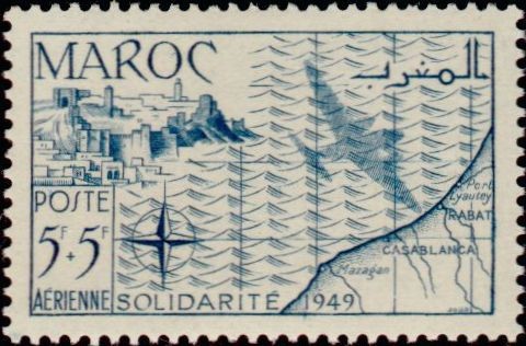
Map of the Northwest
The year 1949 marked a critical phase of socioeconomic mobilization and infrastructural integration along Morocco's northwestern Atlantic coastline under the French Protectorate. Driven by the annual winter solidarity campaigns (Solidarité 1949), administrative authorities focused extensively on raising public relief funds to mitigate post-World War II economic hardships, food insecurity, and inflation across the territory. Concurrently, this period witnessed the rapid modernization of the strategic maritime and coastal corridors linking major urban centers like Casablanca, Rabat, Mazagan, and Port Lyautey. These expanding coastal trade hubs became vital engine rooms for regional economic recovery, channeling essential imports, industrial resources, and humanitarian provisions directly into the territory's recovering domestic markets.
Central to this era of regional connection was the dramatic expansion of commercial and postal aviation networks mapping across the North Atlantic shipping lanes. The northwest coast of Morocco served as an indispensable transcontinental flight corridor and refueling hub, connecting European mainland networks directly with West Africa and South America. Coastal stations and military-grade airfields, particularly around Rabat and Port Lyautey, were heavily integrated into high-speed transit grids that revolutionized mid-century logistics and communications. By pairing these cutting-edge aeronautical developments with state-directed social welfare programs, the post-war administration sought to project an era of technological progress and regional stability, anchoring the nation’s historical coastal strongholds firmly into the global transport network of the twentieth century.
Central to this era of regional connection was the dramatic expansion of commercial and postal aviation networks mapping across the North Atlantic shipping lanes. The northwest coast of Morocco served as an indispensable transcontinental flight corridor and refueling hub, connecting European mainland networks directly with West Africa and South America. Coastal stations and military-grade airfields, particularly around Rabat and Port Lyautey, were heavily integrated into high-speed transit grids that revolutionized mid-century logistics and communications. By pairing these cutting-edge aeronautical developments with state-directed social welfare programs, the post-war administration sought to project an era of technological progress and regional stability, anchoring the nation’s historical coastal strongholds firmly into the global transport network of the twentieth century.